


estables

m@nu
User

Length
19.5 km

Max alt
1740 m

Uphill gradient
636 m
Km-Effort
28 km

Min alt
1341 m

Downhill gradient
685 m
Boucle
No
Creation date :
2021-01-26 09:58:22.536
Updated on :
2021-01-26 13:45:05.249
3h45
Difficulty : Very easy

FREE GPS app for hiking
 SityTrail
IGN / Geographical institutes
SityTrail Plus
The world is yours!
About
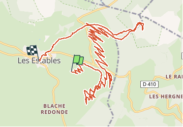
Trail Touring skiing of 19.5 km to be discovered at Auvergne-Rhône-Alpes, Haute-Loire, Les Estables. This trail is proposed by m@nu.
Positioning
Country:
France
Region :
Auvergne-Rhône-Alpes
Department/Province :
Haute-Loire
Municipality :
Les Estables
Location:
Unknown
Start:(Dec)
Start:(UTM)
592126 ; 4972568 (31T) N.
Comments